
FTS360 customers will now be able to receive their GOES data faster, allowing them to quickly view data within 10 seconds after their scheduled or random transmission, send out alerts and make critical decisions that can save lives and property. The high-speed upgrade applies to all GOES CS2 transmitters publishing data to FTS360.
The HRIT (High-Rate Information Transmission) solution implemented by FTS uses a satellite dish to receive the GOES data directly from NOAA transmission via satellite here’s how it works:
As usual, the data from a GOES DCP (datalogger) in the field transmits at its scheduled or random transmission to NOAA. NOAA then processes both the east and west satellite data into a single HRIT feed and sends it back up to both satellites. FTS360 tunes into this feed and gets all the GOES data from both of the satellite systems. While it’s true that the data travels to space and back twice, the resulting time in which the data is available for viewing or alerting within FTS360 is on average between 3-5 seconds (up to 10 seconds in normal operation) after the 10 second timeslot of the DCP has completed.
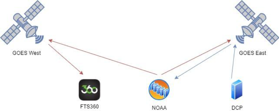
In image 1 above, the DCP is located to see the eastern GOES satellite and transmits via the blue arrows to the satellite. This is received at the NOAA data center and is processed with the GOES west satellite data and retransmitted via the red arrows to both satellites. FTS360 picks up the data from the western satellite which includes the data from the western and eastern satellites.
With reliability always top of mind, FTS has invested in ample battery back-up, as well as multiple options to ensure the HRIT data arrives in the event of a power or internet outage. Secondly, FTS has also built a fallback solution to calling the LRGS services to ensure FTS360 data integrity.
The investment in multiple data telemetry paths including cellular, Iridium and now high-speed GOES aligns with FTS’ plan to bring real-time situational awareness to the FTS360 platform. Alerts can now be sent as the data is sampled, and viewers of the data have an up to the minute picture of current weather conditions using the FTS360 platform.
Have questions about our FTS360 platform? Contact us.