
With climate change impacting the number and severity of wildfires Wildfire Management Agencies and Utilities are looking at how they can strengthen and adjust their wildfire management plans. Wildfire statistics show that U.S. wildfire acreage to have increased from 3.6 million acres in 2014 to 8.8 million acres in 2018. The Ash Creek Fire of 2012 affected 249,562 acres of land, while the NW Oklahoma Complex fire of 2017 charred 779, 292 acres—making it the largest wildfire of the past decade in terms of acreage burned.
In an effort to reduce the loss of property and increase the safety of the public and fire crews, wildfire risk management looks at four stages of emergency management: prevention and mitigation, preparedness, response and recovery. During these four stages weather and fire monitoring are important components to making critical decisions.
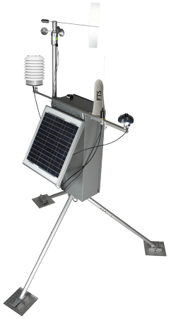
With over 3,500 fixed RAWS stations in North America the RAWS is the standard for fire monitoring, and the Quick Deploy Portable Weather Station (QD) is the fire community’s most widely used weather station for prescribed burns and temporary monitoring applications. The FTS QD is a full weather station with the same reliability and scientific-grade accuracy as the full fixed RAWS, but in a highly portable package. Its portability means that several can be placed at the fire line and rapidly relocated as needed. It offers the same sensors and telemetry options as the fixed RAWS, and all components are interchangeable.
Prescribed Burns
Prescribed burns are a planned and controlled application of fire to a specific land area and is one of the most ecologically appropriate and relatively efficient means for achieving planned public safety and resource management objectives. Prescribed fire can also contribute to achieving air quality and climate action targets by preventing large, intense wildfires and replacing them with more frequent, well-timed, well-planned low-intensity fires.
Key objectives for the use of prescribed fire include:
- Creating and maintaining strategic fuel breaks both in the wildland-urban interface and the landscape,
- Reducing understory fuels, restoring fire-maintained ecosystems,
- Improving wildlife habitat and domestic range, achieving reforestation objectives,
- Wildfire Act and Wildfire Regulation these are defined as resource management open fires.
The QD is used for more accurate spot weather forecasts to provide safe burning, as well as the ability to burn more fuel. Safer burning fuel budgets are based on the acreage burned, so any tool that allows for an increased volume of fuels to be burned safely can pay for itself very quickly.
Multiple portable RAWS set up ahead of the planned burn provide a far higher resolution of data, both in frequency (data transmitted once per hour) and spatially (providing finer, more localized “micro-scale climate” data). The result is continuous measuring of multiple potential burn sites, the ability to start burning as soon as conditions are in prescription, and the confidence of knowing that the burn is being executed as safely as possible.
Accurate and reliable QD data will help to:
- identify hourly trends to best decide when to start/stop ignition
- estimate resources needed for ignition and holding
- plan support for mop-up and patrol needs
- allow agency to stay within given parameters
- archive hourly data is to document weather conditions before, during and after the burn
Active Wildfire Monitoring
Fire Behaviour Analysts use the real-time QD weather data to make critical decisions quickly on direction of an active fire to help keep fire crews safe on the ground. This also allows personnel to focus on tasks without needing to commit to weather monitoring on-site in remote and challenging terrain.
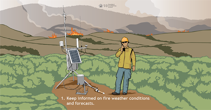
The 10 Standard Firefighting Orders10 Standard Firefighting Orders are organized in a deliberate and sequential way to be implemented systematically and applied to all fire situations. The first standard is to setup a weather station as outlined in the image below. Weather conditions can significantly impact fire behavior, and weather forecasts help firefighters anticipate changes. This Standard Firefighting Order shows a remote automated weather station (RAWS) which sends real-time weather information to incident fire personnel.
The QD RAWS provides:
- more accurate spot weather forecasts in a micro-climate scale
- comparison between actual and forecasted weather
- critical data, right when needed, maximizing crew safety
- ability to move resources to or from threatened areas
- data for initiating burn-out operations or executing contingency plans
Data on Demand and Alerts
The QD Weather Station can be configured with AirTalk radio voice communication which provides real-time data to the fire crew at the burn site via any DF-capable radio (compatible with P25 digital radios). With a simple 3-or 4-digit code, AirTalk broadcasts up-to-the-minute current weather conditions via a clearly audible digitized voice. In addition, instant alerts will be broadcast if any weather parameter threshold is exceeded. This provides real-time decision-making, maximizing fire crew safety and helping prevent escaped burns.
According to the National Interagency Fire Center from January 1 to December 4, 2020 there were 52,934 wildfires compared with 47,673 wildfires in the same period in 2019. About 9.5 million acres were burned in the 2020 period, compared with 4.7 million acres in 2019. With wildfires doubling over last year it is important to continue to look at the key benefits of fire weather monitoring and how the QD technology can make a difference to reducing time needed to make critical decisions that can save lives and property.
As wildfire mitigation planning for next year is well underway contact us to learn more about adding our Quick Deploy Portable RAWS to your existing fire weather monitoring systems for more accurate prescribed burns and spot weather forecasts.